

| | |
Strawberry Pass
El Dorado National Forest (View this site)
El Dorado County, California
El Dorado County, California
Kyburz and Strawberry (North), Kirkwood (South)
Deer Valley, Slick Rock Road, and the Rubicon
Blazen Off Road and Napa Auto (South Lake Tahoe)
Deer Valley, Slick Rock Road, and the Rubicon
Blazen Off Road and Napa Auto (South Lake Tahoe)
Moderate
12.5 miles
6,350' to 8,615'
Open All Year
Waterfall, Painted Rock, Strawberry Pass and
Caples Lake
12.5 miles
6,350' to 8,615'
Open All Year
Waterfall, Painted Rock, Strawberry Pass and
Caples Lake
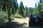
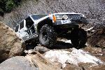
Trail Photographs
(click to view full size)
(click to view full size)
Strawberry Pass is a great scenic trail that connects highways 50 and 88. The
trail is generally run from the North, which allows you to climb up from Highway
50 over Strawberry pass (8,615 feet). The Northern half of the trail is the most
difficult while the Southern half remains easy to moderate
Although the trail is marked as moderate, there are only two tough obstacles on
the trail. The first being a squeeze between a tree and rock and the other known
as Painted Rock. The squeeze can be negotiated by a stock vehicle and a large
flat stone on Pained Rock has been moved allowing access for even slightly
modified vehicles.
Trail Access - Access for Strawberry Pass trail begins to the North on Highway
50 between the towns of Kyburz and Strawberry, at mile marker 42. Both towns
are very small so pay close attention to the mile maker post as you approach
the trail.
Immediately off the highway there is a day use picnic area and restroom to the
right. After crossing the bridge turn right and follow the sign to Strawberry Creek
Tract. The paved road will turn to graded dirt as it follows Strawberry Creek to
the beginning of the trail.
Service Road 11N 19 - After about 0.6 miles there will be a road to the left, this
is Service Road 11N 19. The road is marked an easy to find. This also marks
the beginning of the graded dirt road.
Service Road 10N 13 - Once on 10N 13 you will notice the trail become more
narrow, steep and increasingly difficult. Use caution as off camber sections and
body damage is a possibility. While it is possible to navigate a stock 4x4
through the trail it is not recommended.
Waterfall - This is the first and most difficult obstacle on the trial, now that
Painted Rock has been modified. In the winter and spring the water will make it
down the trail and over the rocks giving this obstacle it's name. Use caution as
sliding one way or the other will most likely leave you high centered. There is a
bypass to the right that a stock vehicle could easily navigate.
Painted Rock - While this obstacle is still the most difficulty on the trail, it is not
the same nail biter that earned it's name. In the past a flat rock in the middle of
the trail forced your rear driver quarter panel into "Painted Rock". The rocks have
been shifted making passage less of a concern.
Squeeze - As you continue up the trail you will be confronted with a tight spot.
This is where a short wheel based vehicle has an advantage. On the right there
is a large rock, risking body damage, and to the left a tree and the trails bank
pinched you in toward the rock. After this point the trails difficulty decreases.
Strawberry Pass - Reaching an elevation of approximately 8625 feet Strawberry
Pass offers some incredible views as you head down toward Caples Lake and
Kirkwood ski resort. There are three gates on your way down the mountain,
don't forget to close them behind you.
Bear left at the maintance station and Highway 88 and Caples Lake is just
ahead.
Trail Maps
38° 47' 27.3" N 120° 09' 07.6" W
38° 47' 06.9" N 120° 08' 54.0" W
38° 46' 06.3" N 120° 06' 38.2" W
38° 45' 49.2" N 120° 06' 07.1" W
38° 45' 40.3" N 120° 05' 48.7" W
38° 35' 37.7" N 120° 05' 49.7" W
38° 43' 42.2" N 120° 04' 18.4" W
38° 43' 33.0" N 120° 02' 51.8" W
38° 47' 06.9" N 120° 08' 54.0" W
38° 46' 06.3" N 120° 06' 38.2" W
38° 45' 49.2" N 120° 06' 07.1" W
38° 45' 40.3" N 120° 05' 48.7" W
38° 35' 37.7" N 120° 05' 49.7" W
38° 43' 42.2" N 120° 04' 18.4" W
38° 43' 33.0" N 120° 02' 51.8" W
Trialhead (North)
Service Road 11N 19
Service Road 10N 13
Waterfall
Painted Rock
Squeeze
Strawberry Pass
Trailhead (South)
Service Road 11N 19
Service Road 10N 13
Waterfall
Painted Rock
Squeeze
Strawberry Pass
Trailhead (South)
GPS Waypoints (GPX)
GPS Track (GPX)
El Dorado National Forest (National Forest Service)
Echo Lake (USGS 24K TOPO)
Pyramid Peak (USGS 24K TOPO)
GPS Track (GPX)
El Dorado National Forest (National Forest Service)
Echo Lake (USGS 24K TOPO)
Pyramid Peak (USGS 24K TOPO)
Directions
From Highway 50 - Northern Access (Sacramento - 80 Miles)
- Head East on Highway 50 toward South Lake Tahoe (80 Miles)
- Turn right at the 42 Mile marker.
From Highway 88 - Southern Access (Stockton - 100 Miles)
- Head East on Highway 88 (100 Miles)
- turn left onto Schneider Cow Camp Road just past Kirkwood and
Caples Lake (0.3 Miles)
- Follow the trail to the right past the maintenance building
| All other products, logos, brand names or companies are trademarks or registered trademarks of their respective companies. |
4x4TrailMaps - All Rights Reserved
| Difficulty Rating: Total Trail Length: Elevation Change: Operating Season: Points of Interest: |
| Nearby Cities: Nearby Trails: Nearby Shops: |
Please allow a few moments to load...
Click the trails and other points of interest for additional information. This map is avalible for download in the "Trail Maps" section.