

| | |
Slick Rock Road
Stanislaus National Forest (View this site)
Alpine County, California
Alpine County, California
Bear Valley
Deer Valley and Strawberry Pass
Blazen Off Road and Napa Auto (South Lake Tahoe)
Deer Valley and Strawberry Pass
Blazen Off Road and Napa Auto (South Lake Tahoe)
Difficult
3.5 miles
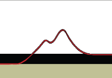
6,730' to 7,400'
Late Spring after snow melt
Silver Creek, Slick Rock, Lake Alpine
3.5 miles
6,730' to 7,400'
Late Spring after snow melt
Silver Creek, Slick Rock, Lake Alpine
Trail Photographs
(click to view full size)
(click to view full size)
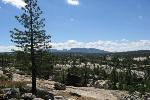
Slick Rock Road is a great scenic route with a few challenges along the way.
Although not as difficult as near by Deer Valley I would argue Slick Rock is more
fun to drive. Along the trail you will find great views of Alpine Lake, Silver Creek
and the Sierra Nevada mountain range.
Slick Rock Road is referred to as a road because it was once a paved service
road. Along the trail there are still areas of concrete visible. Because of its short
length and relative ease the trail only takes a few hours to run but also offers
some great camping opportunities along the trail and Silver Creek.
Trail Access (North) - Slick Rock Road is generally run from the North to the
South beginning to the West of Alpine Lake and ending near Utica Reservoir.
The trail is accessed near a campground one quarter mile West of the Alpine
Lake market.
Trailhead - The trail officially begins a short distance from Alpine Lake and
(0.8 miles) beyond Highway 4. During this section of the trail you will come
across "No Trespassing" / "Private Property" signs, continue on the road as the
signs reference the surrounding property and not the road itself.
Silver Creek Pools - Along the beginning of the trail you will see Silver Creek to
the East and follow it to a clearing that is perfect to setup camp. The water
sheets across the granite and into pools along the river.
Sloped Wall - Use caution in this area as it is slightly off camber. The granite
wall makes for a great photo and a little challenge. Also at this point you are
almost half way through the trail.
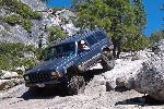
Slick Rock - This section of the trail is steep and long with a short drop at the
bottom. There is a bypass as it maybe difficulty for less equipped vehicles to
make it up from the South to North. Also concrete from the original road can be
seen in this area.
The Stairs - This is the Southern most obstacle on the trail as well as the most
difficult. There are several smaller rocks along the bottom of the obstacle
followed by a medium sized rock in the middle of the trail. After making it over
this rock there are several "steeps" on a large rock to make it up.
Duck Creek Bridge - The Duck Creek Bridge will take you over the North Fork
Stanislaus River. The bridge was reconstructed in 1983 by the Joaquin Jeepers
of Stockton.
Southern Staging Area - The Southern staging area offers plenty of parking
and access for trailers. There are also several surrounding lakes and
reservoirs to fish and kayak. Check with the Forest Service website for motor
and speed restrictions.
Although not as difficult as near by Deer Valley I would argue Slick Rock is more
fun to drive. Along the trail you will find great views of Alpine Lake, Silver Creek
and the Sierra Nevada mountain range.
Slick Rock Road is referred to as a road because it was once a paved service
road. Along the trail there are still areas of concrete visible. Because of its short
length and relative ease the trail only takes a few hours to run but also offers
some great camping opportunities along the trail and Silver Creek.
Trail Access (North) - Slick Rock Road is generally run from the North to the
South beginning to the West of Alpine Lake and ending near Utica Reservoir.
The trail is accessed near a campground one quarter mile West of the Alpine
Lake market.
Trailhead - The trail officially begins a short distance from Alpine Lake and
(0.8 miles) beyond Highway 4. During this section of the trail you will come
across "No Trespassing" / "Private Property" signs, continue on the road as the
signs reference the surrounding property and not the road itself.
Silver Creek Pools - Along the beginning of the trail you will see Silver Creek to
the East and follow it to a clearing that is perfect to setup camp. The water
sheets across the granite and into pools along the river.
Sloped Wall - Use caution in this area as it is slightly off camber. The granite
wall makes for a great photo and a little challenge. Also at this point you are
almost half way through the trail.
Slick Rock - This section of the trail is steep and long with a short drop at the
bottom. There is a bypass as it maybe difficulty for less equipped vehicles to
make it up from the South to North. Also concrete from the original road can be
seen in this area.
The Stairs - This is the Southern most obstacle on the trail as well as the most
difficult. There are several smaller rocks along the bottom of the obstacle
followed by a medium sized rock in the middle of the trail. After making it over
this rock there are several "steeps" on a large rock to make it up.
Duck Creek Bridge - The Duck Creek Bridge will take you over the North Fork
Stanislaus River. The bridge was reconstructed in 1983 by the Joaquin Jeepers
of Stockton.
Southern Staging Area - The Southern staging area offers plenty of parking
and access for trailers. There are also several surrounding lakes and
reservoirs to fish and kayak. Check with the Forest Service website for motor
and speed restrictions.
Trail Maps
Waypoint Coordinates
(click to download)
(click to download)
38° 28' 40.9" N 120° 00' 27.9" W
38° 28' 07.5" N 120° 00' 40.2" W
38° 27' 32.8" N 120° 00' 18.1" W
38° 27' 20.1" N 120° 00' 17.8" W
38° 26' 43.8" N 120° 00' 46.5" W
38° 26' 33.1" N 120° 00' 39.5" W
38° 26' 30.8" N 120° 00' 30.5" W
38° 26' 26.3" N 120° 00' 28.5" W
38° 28' 07.5" N 120° 00' 40.2" W
38° 27' 32.8" N 120° 00' 18.1" W
38° 27' 20.1" N 120° 00' 17.8" W
38° 26' 43.8" N 120° 00' 46.5" W
38° 26' 33.1" N 120° 00' 39.5" W
38° 26' 30.8" N 120° 00' 30.5" W
38° 26' 26.3" N 120° 00' 28.5" W
Northern Trail Access
Trailhead Sign
Silver Creek Pools
Sloped Wall
Slick Rock
The Stairs
Duck Creek Bridge
Southern Staging Area
Trailhead Sign
Silver Creek Pools
Sloped Wall
Slick Rock
The Stairs
Duck Creek Bridge
Southern Staging Area
Slick Road Road & Waypoints (Google Earth)
GPS Waypoints (GPX)
GPS Track (GPX)
Stanislaus National Forest (National Forest Service)
Tamarack (USGS 24K TOPO)
GPS Waypoints (GPX)
GPS Track (GPX)
Stanislaus National Forest (National Forest Service)
Tamarack (USGS 24K TOPO)
Directions
From Highway 4 - Northern Access (Stockton - 100 Miles)
- From Highway 99 South Exit Highway 4 East (95 Miles)
- Turn right at NF 7N17
- The trailhead starts to the Northwest of Alpine Lake
- Just before the trailhead sign you will pass a "private property" sign
the road is open to the public
To Highway 4 - Southern Access (Trails End - 9.5 Miles)
- Continue on NF 7N17 (2 Miles)
- Turn right onto NF 7N38 (4.3 Miles)
- NF 7N38 becomes NF 7N01 (2.6 Miles)
- Turn right onto Spicer Meadow Road to Highway 4 (3 Miles)
| All other products, logos, brand names or companies are trademarks or registered trademarks of their respective companies. |
4x4TrailMaps - All Rights Reserved
| Difficulty Rating: Total Trail Length: Elevation Change: Operating Season: Points of Interest: |
| Nearby Cities: Nearby Trails: Nearby Shops: |
Please allow a few moments to load...
Click the trails and other points of interest for additional information. This map is avalible for download in the "Trail Maps" section.
| | |